


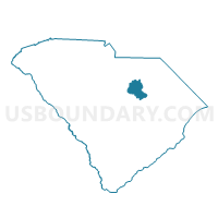
Ionia Voting District, Lee County, South Carolina
About
Outline

Summary
| Unique Area Identifier | 666241 |
| Name | Ionia Voting District |
| County | Lee County |
| State | South Carolina |
| Area (square miles) | 20.41 |
| Land Area (square miles) | 20.34 |
| Water Area (square miles) | 0.07 |
| % of Land Area | 99.64 |
| % of Water Area | 0.36 |
| Latitude of the Internal Point | 34.21585120 |
| Longtitude of the Internal Point | -80.40748760 |
Maps


Graphs
Select a template below for downloading or customizing gragh for Ionia Voting District, Lee County, South Carolina


Neighbors
Neighoring Voting District (by Name) Neighboring Voting District on the Map
- Antioch Voting District, Kershaw County, SC
- Cedar Creek Voting District, Lee County, SC
- Cherlotte Thompson Voting District, Kershaw County, SC
- Hickory Hill Voting District, Lee County, SC
- Rattlesnake Springs Voting District, Lee County, SC
- Schrocks Mill/Lucknow Voting District, Lee County, SC
- Spring Hill Voting District, Lee County, SC
Top 10 Neighboring County Subdivision (by Population) Neighboring County Subdivision on the Map
- Bishopville CCD, Lee County, SC (10,455)
- Ashwood CCD, Lee County, SC (4,001)
- Boykin CCD, Kershaw County, SC (2,987)
Top 10 Neighboring Unified School District (by Population) Neighboring Unified School District on the Map
Top 10 Neighboring State Legislative District Lower Chamber (by Population) Neighboring State Legislative District Lower Chamber on the Map
Top 10 Neighboring State Legislative District Upper Chamber (by Population) Neighboring State Legislative District Upper Chamber on the Map
Top 10 Neighboring 111th Congressional District (by Population) Neighboring 111th Congressional District on the Map
Top 10 Neighboring Census Tract (by Population) Neighboring Census Tract on the Map
- Census Tract 9202, Lee County, SC (4,866)
- Census Tract 9204, Lee County, SC (4,001)
- Census Tract 9707, Kershaw County, SC (2,987)